Overview
While many outsiders think of Iowa as a “flyover state” with the same landscape as far as the eye can see, us Iowans know that Iowa is unique from corner to corner.
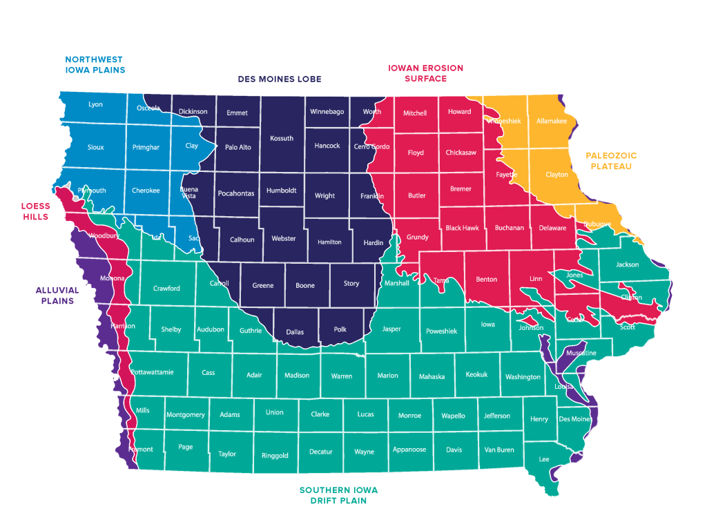
Iowa’s landscape was largely shaped by glaciers. Those ancient sheets left behind different soils, aquifers, rock formations, and more. Geologists today now group areas by specific qualities that resulted from glacial activity (or lack of it).
Des Moines Lobe
The youngest glaciated region, covering north-central Iowa, is characterized by flat, poorly drained terrain with rich, dark soils that are some of the most productive in the world. Because the glacier retreated so recently (in geologic terms), the landscape hasn’t had time to develop natural drainage, which means tile drainage is virtually a necessity.
Conservation efforts in this area focus on drainage due to “prairie potholes” – sloping dips in the land that once held wetlands. The conservation challenge here is managing tile drainage to reduce nitrate and phosphorus loading into waterways — practices like saturated buffers, bioreactors, and wetland restoration are increasingly critical tools.
Southern Iowa Drift Plain
Older glaciation and centuries of erosion have carved this region into rolling hills and deeply cut valleys, with thinner, more erodible soils prone to runoff. The terrain demands a tailored approach to conservation — contour farming, terraces, and cover crops are essential to hold soil on those slopes and keep sediment out of streams and rivers. Southwest Iowa has deep aquifers, some of them too deep to access.
In SW Iowa especially, conservationists are working to bring cattle back to the land since the landscape fits beautifully with natural grazing patterns.
Paleozoic Plateau
The northeast corner of Iowa is sometimes called “little Switzerland” for it’s beautiful bluffs and elavation changes. It features karst topography with sinkholes and fractured bedrock, meaning water moves quickly underground with very little natural filtration. This region is particularly sensitive because any nutrient or input applied to fields can reach groundwaterwith alarming speed. This is a priority area for livestock manure management and well protection.
People who live in this area and use private wells should also be consistent with well testing to make sure their wells are not contaminated from the soft structure underground. Significant efforts are being made by DNR in NE Iowa to protect and restore natural trout streams.
Loess Hills
Running along Iowa’s western border, these formations are built from wind-deposited silt that is extraordinarily fertile but also among the most erosion-prone soils on earth. Even modest slopes can lose topsoil rapidly without permanent vegetation and careful grazing or crop management, making soil retention the defining conservation challenge of this region.
The Loess Hills is a rare gem – not only in Iowa’s landscape – but worldwide. The only similar landscape known to exist is in China, along the valley of the Yellow River where massive deposits of loess occur.
Northwest Iowa Plains
This region, covering the northwest corner of the state, sits between the Des Moines Lobe and the Missouri River valley and shares some characteristics of both. Glaciated but older than the Des Moines Lobe, the landscape has had more time to develop natural drainage, resulting in gently rolling terrain with deep, fertile soils — primarily Galva and Marcus series — that are well-suited to row crop production.
The region’s proximity to the Missouri River corridor also means some areas carry wind-deposited loess influence, contributing to high organic matter content in the topsoil. Drainage, while less problematic than the Des Moines Lobe, still requires active management. Cover crops and grassed waterways are especially valuable tools here for keeping nutrients and sediment in the field.
Iowan Erosion Surface
Covering a broad swath of northeast-central Iowa, this region is one of the most geologically interesting in the state. It was glaciated, but unlike the younger Des Moines Lobe, it has been exposed to thousands of years of erosion that smoothed and reshaped the landscape into a gently undulating plain dotted with boulders — called “erratics” — left behind as the glacier melted.
The soils here, including the Kenyon and Clyde series, are productive but variable, shifting between well-drained uplands and poorly drained swales within short distances. That variability creates precision management challenges for farmers trying to optimize inputs across a single field. From a conservation standpoint, the region’s natural topographic diversity offers opportunity — restored wetlands and prairie strips fit naturally into low-lying areas, providing water quality benefits without taking highly productive ground out of production.
Alluvial Plains
The alluvial plains are the river bottom lands deposited over thousands of years by Iowa’s bordering waterways — the Missouri, and Mississippi Rivers. These bottomland soils, built from layer upon layer of sediment carried and dropped by floodwaters, are among the deepest and most fertile in the state, with some profiles showing productive topsoil extending several feet down. Conservation challenges here center on keeping nutrients and sediment from entering adjacent waterways.